
Okanagan Lakeshore Flooding
Published: May 18, 2018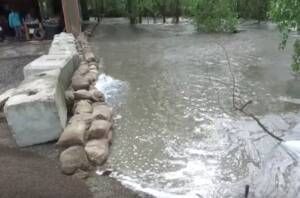
Photo: Darren Handschuh
Prepare For Flooding… AGAIN!
Remember the flooding of 2017? Those who lived in the North Okanagan at that time sure do! Last year, Okanagan Lake rose to a level of 343.25m which was just shy of the all-time high water mark set in 1948 of 343.28m.
This year the focus for flooding had been on the Southern Interior and Grand Forks areas. News about Okanagan Lake levels and how high it could get haven’t been in the news or communicated much at all. So, we should be safe right? Not so fast.
The City of Vernon and the City of Kelowna have issued warnings. Residents along creeks, waterways and lakes should prepare for high water that may exceed even the levels we saw last year.
Both cities have asked residents to prepare for high water and flooding possibly even higher than last year. Higher than normal snowpacks, above average seasonal temperatures and the possibility of wet weather are to blame. Residents of Okanagan Landing, Adventure Bay, Tronson Road, Fintry and Westside should take immediate precautions.
Flooding in the Osoyoos region has slowed the draining of Okanagan Lake. The dam has decreased output by a third to 37 cubic metres per second. Max drain levels are at 60 cubic metres per second.
Here are some helpful links to monitor going forward:
Central Okanagan Emergency Map – Sandbag locations, Kelowna, Lake Country, Westside
North Okanagan Emergency Information – Sandbag locations, Vernon and North Okanagan
Live Lake Updates – Lake levels and flow information
Daily lake level graph – Compare to last year and full pool
As of May, 18 Okanagan Lake is at 342.45m just 4.4cm shy of ‘full pool’. Boaters are urged to follow safety precautions and make no wake near shorelines along the lake.